Deviation Actions


Description
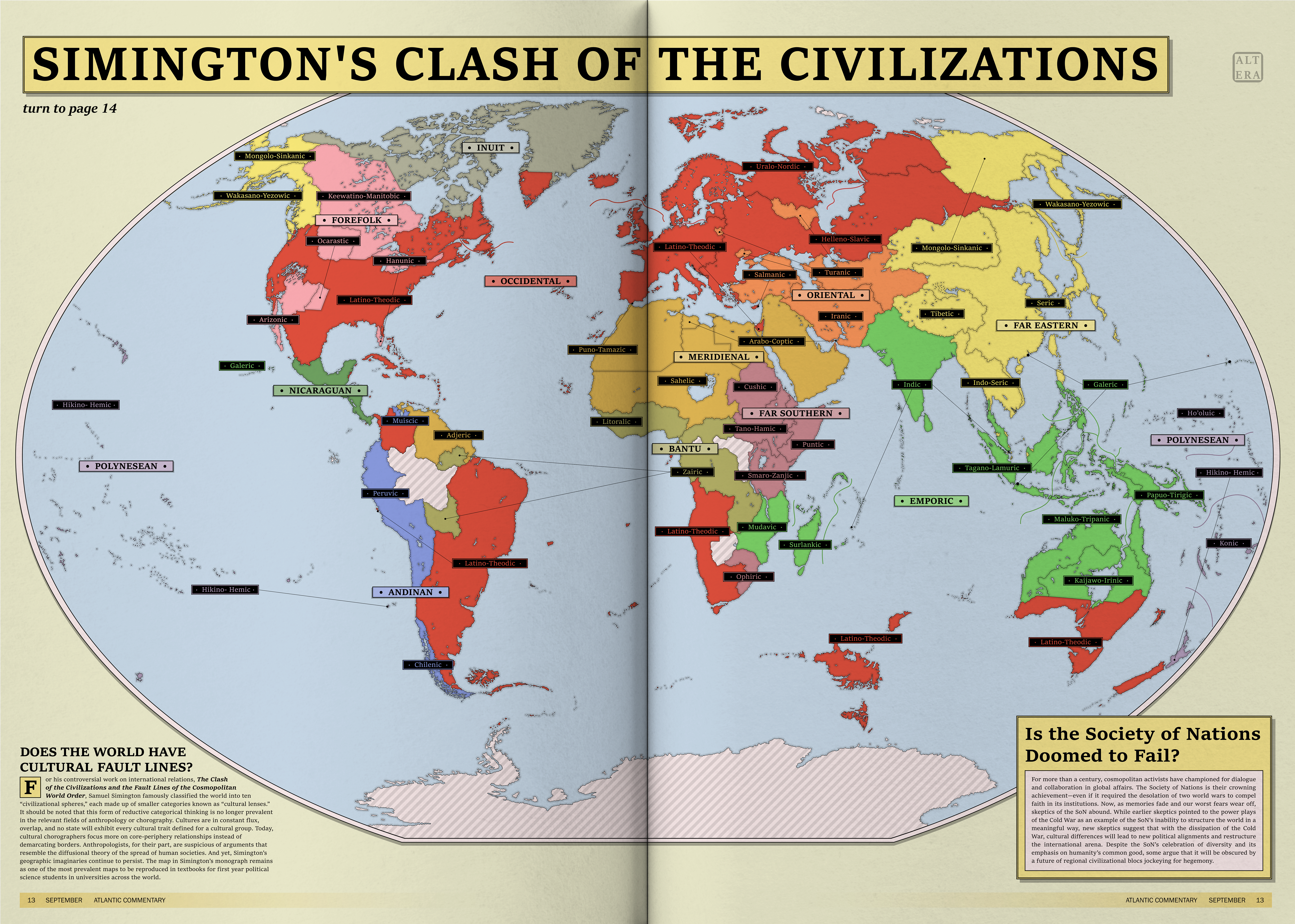
This is a spoof of Huntington's Clash of the Civilizations for Atlas Altera. The point of our project is to tell facts through storytelling, because how reality is portrayed often hides the truth. The blurbs on this 90s-style magazine spread should give a good critical cursory overview/preamble for the map and the kind of pseudo-cultural geographical work behind Huntington's theory. In a nutshell, this map is about "civilizational spheres" and "cultural lenses." Behind the groupings, however, is reductive Western geographic imaginaries—think Orientalism but writ large.
Why did we attempt to make a map like this? Cultural geography maps like this are "fun" and "intriguing" to most people, though they are problematic. Inherently they are imbibed with prejudices and unhealthy assumptions of how the world works. Divvying up the world into categories is not necessarily the issue. The issue is that culture at such a scale is full of ironies and overlap, which make demarcations or the drawing up of borders futile. There are several traits to each cultural group defined at this scale. And every time the geographer considers a new cultural component or trait, the borders shift and the units of measurement—the countries—fall into a different layout. Today, only political scientists or international relations theorists ever make reference to such a worldview. Hopefully it's to challenge or complicate Huntington. No contemporary anthropologist does the same by attempting to simplify the world this way. Even archaeologists have distanced themselves from the "Cradles of Civilization," pivoting instead to the concept of "Centres of Domestication.
On the flipside, however, is the fact that people do still use this kind of thinking as a heuristic for understanding differences in the world. If there is an Orientalism, there is definitely an assumed Occidentalism in our vocabulary. Thus, this imaginary map does not depict empirical facts in an imaginary world, but rather, is an imaginary map that depicts imaginaries—social constructs—that are nevertheless treated as fact in an imaginary world. This is how the Westerners of Altera see or reference the world whenever they try to ascribe claims about regional cultural differences.
To see the grander world maps of our project, check out www.atlasaltera.com. There’s also a humbler YouTube channel.
Let me guess:
Occidental = The Western World
Forefolk = North American natives
Inuit
Nicaragua = Mesoamerica
Andes = South American natives
Meridienal = The Arab World
Oriental = Iran and the Turkics
Far Southern = The (in the words of RvBOMally) Spine of Africa
Bantu
Emporic = Seemingly the entire Indian Ocean
Far Eastern = East Asian
Polynesian